Log in
All resources
Create a design
1,097 Free Artworks of Coats Of Arms On Maps
bibliothèque nationale de france
baroque
atlas novus (blaeu)
engravings of topographia braunschweig lüneburg
maps with cartouches
maps by willem and johannes blaeu
paper
joan blaeu
maps by pieter van der keere
maps in the british museum
kaart figuratief delft, tweede staat
collections of stadsarchief delft
pales of aragon in civic heraldry of catalonia
coats of arms of catalonia
topographia westphaliae (merian)
baroque
blaeu atlas of scotland 1654
coats of arms on maps
coat of arms of von rogendorff by albrecht dürer
german renaissance
old maps of emden
baroque
topographia franconiae (merian)
baroque
engravings of topographia braunschweig lüneburg
baroque
old maps of zwolle
atlas van loon
coats of arms on maps
atlas novus (blaeu)
coats of arms on maps
1645 maps of belgium
catalan atlas, 1959 reproduction
coats of arms on maps
17th-century maps of cornwall
maps in the british museum
topographia braunschweig lüneburg (merian)
baroque
engravings of topographia braunschweig lüneburg
baroque
topographia braunschweig lüneburg (merian)
baroque
wienhausen monastery
baroque
merian sueviae
baroque
engravings of topographia braunschweig lüneburg
baroque
topographia bohemiae moraviae et silesiae (merian)
baroque
engravings of topographia braunschweig lüneburg
baroque
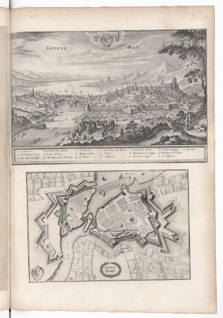
old maps of geneva
baroque
topographia braunschweig lüneburg (merian)
baroque
engravings of topographia braunschweig lüneburg
baroque
atlas maior, vol 1 (northern europe, norway, and denmark) - joan blaeu, 1667 - bl 114.h(star).1
1667 maps
map of maastricht by willem and johannes blaeu (1649)
sint-antoniuseiland (maastricht)
history of waldeck (am edersee)
coats of arms of waldeck family
royal coats of arms of norway
hieronymus scholeus
topographia braunschweig lüneburg (merian)
baroque
engravings of topographia braunschweig lüneburg
baroque
17th-century maps of cambridgeshire
old county maps of cambridgeshire
maps by willem and johannes blaeu
old maps of groningen (city)
maps of aalst by braun & hogenberg
coats of arms on maps
coats of arms of austrian silesia
atlas maior
the generall historie of virginia (john smith)
1624 books from london
coats of arms on maps
atlas novus (blaeu)
bibliothèque nationale de france
maps of goa by linschoten
1610s maps of the netherlands
old maps of friesland
arnold van langren map of southwest africa
cartouche (cartography)
old maps of the polish-lithuanian commonwealth
historical coats of arms of poland
16th-century maps of amsterdam
lodovico guicciardini
maps of cologne by braun & hogenberg
coats of arms of cologne
old maps of freiburg im breisgau
baroque
china veteribus sinarum regio nunc incolis tame dicta
old maps of china in harvard map collection
merian helvetiae, rhaetiae et valesiae
baroque
portolan charts by willem and johannes blaeu
old maps of friesland
historic views of limburg an der lahn
baroque
old maps of the tsardom of russia
national coat of arms of russia
topographia alsatiae (merian)
baroque
1610s maps of the netherlands
maps with cartouches
17th-century maps of sweden
1660s maps of norway
topographia bohemiae moraviae et silesiae (merian)
baroque
carta hydrographica y chorographica de las yslas filipinas
baroque painting
krimpenerwaard
swanenburg
portrait of george washington by giuseppe perovani
1790s maps of washington, d.c.
coats of arms of archbishops of the roman catholic archdiocese of esztergom-budapest
maps of esztergom by braun & hogenberg
coats of arms of grand duchy of lithuania
magni ducatus lithuaniae
victor levasseur - maps of france
neoclassicism,romanticism
topographia austriacarum (merian)
baroque
17th-century maps of silesia
coats of arms on maps
maps by pieter van der keere
old maps of utrecht
cartouches by willem and johannes blaeu
historical coats of arms
bibliothèque nationale de france
maps of goa by linschoten
maps of gallipoli by braun & hogenberg
maps in the british museum
bibliothèque nationale de france
maps of goa by linschoten
coats of arms of grand duchy of lithuania
magni ducatus lithuaniae
maps of haarlemmerhout
old maps of haarlem
17th-century maps of frankfurt am main
maps by willem and johannes blaeu
maps in the british museum
1610s maps of ireland
map of l'evesché du mans by jaillot and cordier
bibliothèque nationale de france
map of l'evesché du mans by jaillot and cordier
bibliothèque nationale de france
map of l'evesché du mans by jaillot and cordier
bibliothèque nationale de france
old maps of nassau
salomon rogiers
juan de la cruz cano y olmedilla
1755 maps of north america
henri le roy (1579-)
diocese of aire
map of l'evesché du mans by jaillot and cordier
bibliothèque nationale de france
maps of duisburg by braun & hogenberg
maps of emmerich by braun & hogenberg
coats of arms of grand duchy of lithuania
magni ducatus lithuaniae
maps by pieter van der keere
old maps of zutphen
maps by willem and johannes blaeu
1638 maps of asia
historical royal coats of arms of the netherlands
maps by willem and johannes blaeu
coats of arms of grand duchy of lithuania
magni ducatus lithuaniae
world war ii posters from the united kingdom
her majesty's stationery office collection
atlas maior, vol 2 (sweden, russia, poland, eastern europe, and greece) - joan blaeu, 1667 - bl 114.h(star).2
coats of arms of the tsardom of russia
maps of the ganges river
old maps of bengal
maps of spain by tomas lopez
old maps of gran canaria
maps by alexis-hubert jaillot
maps by guillaume sanson
map of the circle of austria by sanson
1700s maps of austria
maps of milan by braun & hogenberg
baroque
maps of rotterdam by braun & hogenberg
maps of delft by braun & hogenberg
prints of cartouches in the rijksmuseum amsterdam
maps in the rijksmuseum amsterdam
maps in the british museum
maps by john speed
1610s maps of the holy roman empire
jacques surhon
library of the university of vienna
map of vienna by jacob hoefnagel
maps by willem and johannes blaeu
laurens reael
old maps of westphalia
johannes gigas
dutch 17th-century prints in the rijksmuseum amsterdam
old maps of roermond
dutch 17th-century prints in the rijksmuseum amsterdam
old maps of roermond
history of the low countries
netherlands in the 1630s
maps of arnhem by braun & hogenberg
maps of venlo by braun & hogenberg
301 - 400 of 1,097
Next page
/ 11


![Mediolanum / [M. Merian], Matthäus Merian, 1638](https://cdn.creazilla.com/illustrations/10000493832/mediolanum-m-merian-matth-us-merian-1638-sm.jpg)


